IoT water level monitoring on the Danube floodplain: Meratch with VÚVH
Every year, controlled releases of water spill from the main Danube channel into the side arms and forests of the Slovak floodplain. They are there to keep a damaged ecosystem alive, by recreating the natural flood pulse that damming and regulation removed from the river. Getting those releases right, at the right level, for the right duration, depends on knowing what is actually happening out in the floodplain while it is happening.
The Research Institute of Water Management (VÚVH) asked Meratch to build that measurement layer. We installed 12 high-precision IoT water-level sensors across the Slovak Danube floodplain and connected them to a public data platform, so every stakeholder works from the same live numbers.
- Client
- VÚVH, the Research Institute of Water Management (Slovakia)
- Use case
- Real-time monitoring of simulated flooding in the Danube floodplain
- Sensors deployed
- 12 Meratch radar water-level sensors, millimetre-accurate
- Connectivity
- NB-IoT, hourly readings to a centralised server
- Battery life
- Over 5 years in this application (no routine maintenance)
- Public data
- Live dashboard at vuvh.meratch.com, with alerts on threshold events
Context: the Danube floodplain and why it still needs flooding
The Danube is the second-longest river in Europe and the most international, running through ten countries before reaching the Black Sea. On its Slovak stretch, between Bratislava and Komárno, it spreads into one of Central Europe's most valuable inland floodplain systems, a mosaic of side arms, forests, meadows, and wetlands that evolved with the river's seasonal flood pulse.
Damming and channel regulation, including the Gabčíkovo waterworks, stabilised the main flow but removed that pulse. Without periodic flooding, floodplain forests dry out, side arms silt up, spawning habitats disappear, and the ecological character of the area starts to drift away from what the river is meant to support.
Simulated flooding is the response. Controlled releases of water from the main channel are sent through the floodplain at specific times of year, at specific discharge profiles, to mimic the natural flood wave the river no longer delivers. This is not a disaster scenario, it is a deliberate ecological intervention that has been part of the Slovak Danube's management regime since the 1990s.
The challenge:
You cannot manage what you cannot measure in real time
Simulated flooding only works if the discharge, timing, and distribution match what the ecosystem needs. Too little water and the intervention fails to trigger the biological response it is designed for. Too much, or for too long, and you risk damaging infrastructure, bank stability, or habitats at the edge of the floodplain. A release that succeeds in one side arm can easily under-deliver in another if it is not tracked across the whole system.
Until recently, VÚVH and its partners monitored these events largely by hand. Field teams travelled out to staff gauges and reference points, read the water level, recorded it, and brought the records back. This approach had three limits that increasingly bit into the quality of the programme:
- Sparse data. A handful of readings per day cannot capture how a flood wave actually propagates through the floodplain, and cannot show where water is pooling, stalling, or retreating.
- Inaccessibility during peak flow. The moments when the data matters most are the moments when physically reaching the monitoring sites is slow, awkward, or unsafe.
- Delayed insight. By the time manual readings were collated and shared, the event was often over. Operational decisions during a release, and evidence to defend those decisions afterwards, both suffered.
VÚVH needed a way to see the whole floodplain at once, continuously, and to share that view with partners, researchers, and the public.
The solution:
12 radar sensors, one public platform
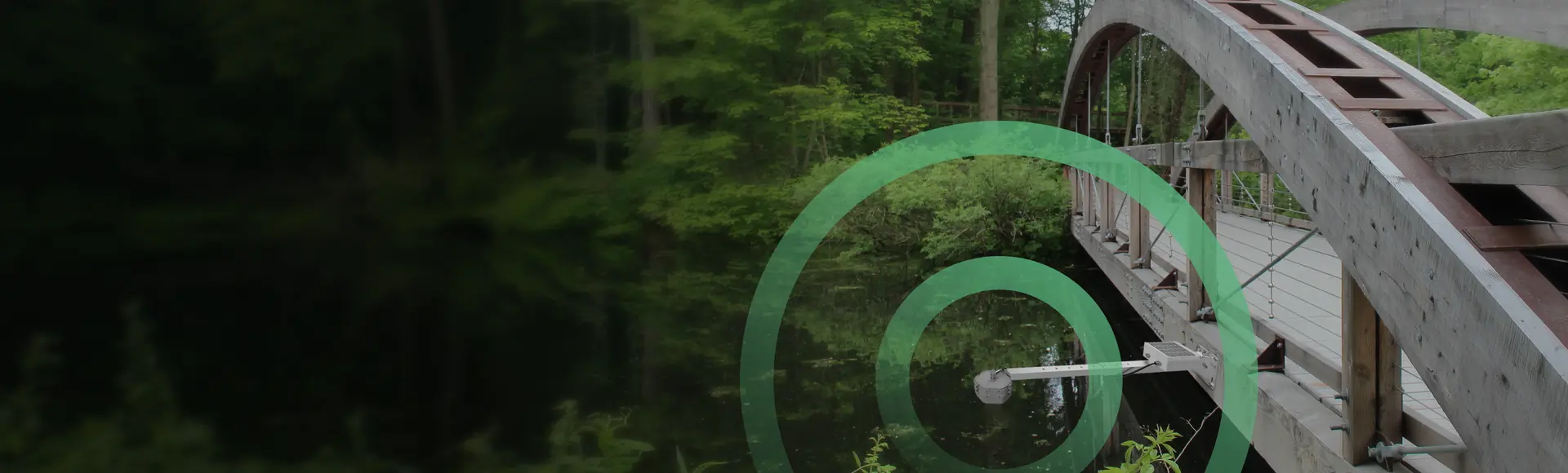
Meratch designed and delivered an IoT water-level network sized for the Danube floodplain. Twelve radar water-level sensors were installed at hydrologically meaningful points across the system, chosen together with VÚVH so that each reading represents a distinct part of the floodplain, from main channel cross-sections to side-arm entries and interior forest stands.
Each sensor reads from above the water surface using non-contact 60 GHz nanoradar, so nothing sits in the water to foul, corrode, or be torn out during a release event. Readings are transmitted hourly over NB-IoT to a centralised server, where they flow into a dedicated Meratch-built data platform and a public web application at vuvh.meratch.com. Threshold-based alerts notify operators the moment a reading crosses a level of interest.
Battery life in this application exceeds five years, even with the hourly transmission cadence, so the network runs without routine field maintenance. That matters on the Danube floodplain, where revisiting a site in the middle of a controlled release is expensive and rarely the best use of a research team's time.
- Measurement range
- 0.2 m to 22 m
- Resolution / precision
- 1 mm resolution, ±2 mm precision (independently verified)
- Measurement method
- Non-contact 60 GHz nanoradar, 10° beam width
- Protection rating
- IP68 / IK10 (fully sealed, impact resistant)
- Operating temperature
- −40 °C to +75 °C
- Connectivity (this deployment)
- NB-IoT, hourly transmission; LoRaWAN and 2G available on the platform
- Power & battery life
- 3.6 V, 14 Ah (19 Ah option); over 5 years at hourly cadence, up to 10 years at lower cadence
- Form factor
- Φ106 mm × 63 mm, 300 g, ultrasonically welded housing
- Installation
- Multiple mounting options via adapter; typical install around 20 minutes
Specifications per Meratch Radar Level Sensor datasheet (EN, 2025-08). The Danube floodplain deployment uses NB-IoT at hourly cadence, which is why the 5-plus year battery figure is the reference for this application.
Outcomes: what changed for VÚVH
From field visits to a live picture
The team no longer depends on manual reads to understand an event. During a simulated release, operators can watch the wave propagate across the floodplain in near real time, compare what is happening in each side arm, and adjust management expectations as the event develops instead of after it.
Shared, public data
The public web application at vuvh.meratch.com makes the same data available to researchers, partner institutions, and interested members of the public. This is a meaningful change for a research programme whose legitimacy depends on being visible and auditable. Everyone is looking at the same numbers at the same time.
Proactive alerts, not reactive reports
Threshold-based notifications flag the moments when intervention or observation is warranted, so field time is spent on decisions, not on checking whether a level is still where it should be. Over a season, this adds up to a material reduction in routine fieldwork and a material increase in the quality of event documentation.
IoT technology has set new benchmarks in floodplain management. Automated data collection has freed resources for analysis and intervention, and the real-time view has refined flood safety protocols.
From the published Meratch × VÚVH case study (2024)
Why this matters beyond the Danube
The floodplain-monitoring problem is not unique to the Danube. Any controlled river-ecosystem programme in Europe, whether connected to a dam, a barrage, a water-diversion scheme, or a nature-restoration project, faces the same basic measurement challenge: a large, partially inaccessible area that has to be understood in real time, with data that is defensible, sharable, and available long after the event.
The architecture used on the Danube (radar sensors on NB-IoT, hourly transmission, a dedicated data platform, public access) transfers cleanly to any of those sites. The same radar sensor underpins other Meratch deployments, from cross-border flash-flood warning in the LIFE FLOPRES project to municipal wastewater monitoring in Bratislava: the hardware is designed for outdoor exposure, the connectivity works in remote and vegetated areas, and the public-platform layer is the piece that closes the gap between measurement and decision.
Looking at a similar project?
If you are a research institute, river-basin authority, or environmental engineer planning an IoT water level monitoring programme, the Meratch team can help you scope the sensing network, the data platform, and the public-facing layer end to end.