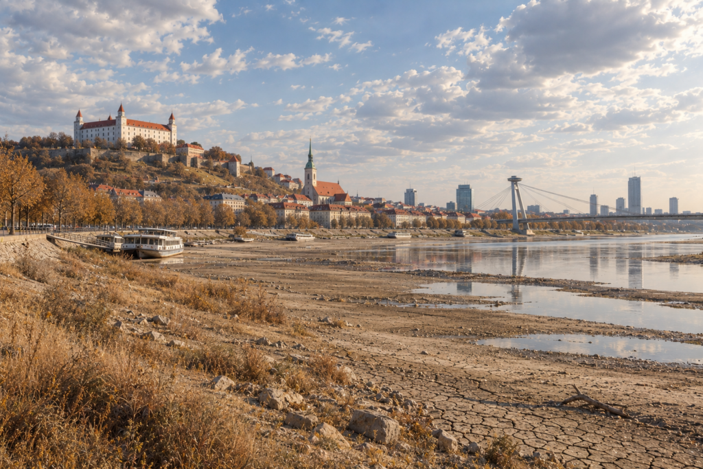
2026 brought Slovakia its driest start to a year in 65 years, a new national temperature record, and a summer with no match in the measured record. But the data point to something that does not fit the usual story about drought: the main cause was not that we get less and less rain. The main cause is that the atmosphere is getting thirstier. And that determines which measures will work — and which will not.
Part one — what happened, and why
A year that began with an empty store
The 2026 drought did not begin in summer. It began in December 2025.
December 2025 to May 2026 was the driest December–May period in Slovakia in 76 years: 233 mm, or 65 % of the normal. The same record fell for Central Europe as a whole (68 % of normal). We therefore entered the growing season not at zero but in deficit — the soil profile that crops draw on in July and August was never refilled in spring.
By 11 September 2026 the year-to-date rainfall total over Slovakia stood at 349 mm against a long-term median of 541 mm, just under 65 %. That is the driest start to a year in the 1961–2026 record; the previous minimum belonged to 2003 (401 mm), and 2026 sits a further 51 mm below it. Even the heavy rain of 11 September — areally the wettest day since the start of summer — removed less than a tenth of the deficit and did not change the year’s rank in any window longer than a month.
A summer that rewrote the records
Summer 2026 was not the warmest on record in mean temperature — it came third, behind 2024 and 2022. In heat extremes, however, it stands alone:
| indicator (summer 2026) | value | rank 1961–2026 |
| mean of station maxima | 37.4 °C (normal 33.0) | 1st — record |
| days with Tmax ≥ 35 °C | 9.7 per station (normal 1.2) | 1st — record |
| days with Tmax ≥ 38 °C | 2.9 per station (normal 0.1) | 1st — record |
| nights with Tmin ≥ 24 °C | 0.3 per station | 1st — record |
| precipitation total | 57 % of normal | 2nd–3rd driest |
| absolute maximum | 42.2 °C — Dolné Plachtince, 6 Aug | new national record |
Of 70 stations with records longer than 40 seasons, 58 broke their own all-time maximum and 49 their own record for days above 35 °C. Hurbanovo — a station with a record going back to 1872 — recorded a mean summer temperature of 24.3 °C, 53 tropical days, and 29.9 mm of rain for the whole summer. The previous minimum in 154 years of measurement was 73.2 mm. The longest continuous dry spell there lasted 42 days.
Heat extremes: it is not only about the days
Summer 2026 was not uniform. It rested on two exceptional heatwaves with a nearly normal July between them:
| wave | days | peak | days ≥ 35 °C | days ≥ 40 °C | tropical nights (total) |
| 19 Jun – 1 Jul | 13 | 41.3 °C (30 Jun) | 9 | 2 | 150 |
| 16–19 Jul | 4 | 36.6 °C | 2 | 0 | 13 |
| 29 Jul – 7 Aug | 10 | 42.2 °C (6 Aug) | 10 | 4 | 181 |
The August wave was the most intense: on all ten days at least one station exceeded 35 °C, and on average 80 % of the network passed 30 °C. On 5 August, 26 stations exceeded 40 °C at once — before 2026, the 40 °C mark had been reached in Slovakia three times in the entire measurement history.
The heat did not stay in the lowlands. Records fell in the mountains too: Lom nad Rimavicou at 1,018 m recorded 7 tropical days (previous best 3) and 9 tropical nights (previous best 4). Lowlands below 200 m averaged 43 tropical days — almost half the summer — and nearly 17 days above 35 °C.
The nights, however, were decisive. Bratislava-Koliba recorded 26 tropical nights, six of them with a minimum above 24 °C; the national record for the highest night-time minimum fell at Skalica on 5 August — 28.4 °C. And this is where the attribution signal is strongest: tropical nights in Slovakia are now almost 30× more frequent than in a pre-industrial climate, while tropical days are “only” 4.3× more frequent. For health the first number matters more — heatwaves kill when the body gets no chance to cool down overnight.
Heat stress is measured by the UTCI, which combines temperature with humidity, wind and radiation. The average station recorded 116 hours of very strong heat stress (UTCI ≥ 38 °C) in summer 2026; at Dudince it was 294 hours. At four stations the index passed 46 °C at least once — the threshold of extreme heat stress; the maximum of 46.5 °C was reached at Hurbanovo.
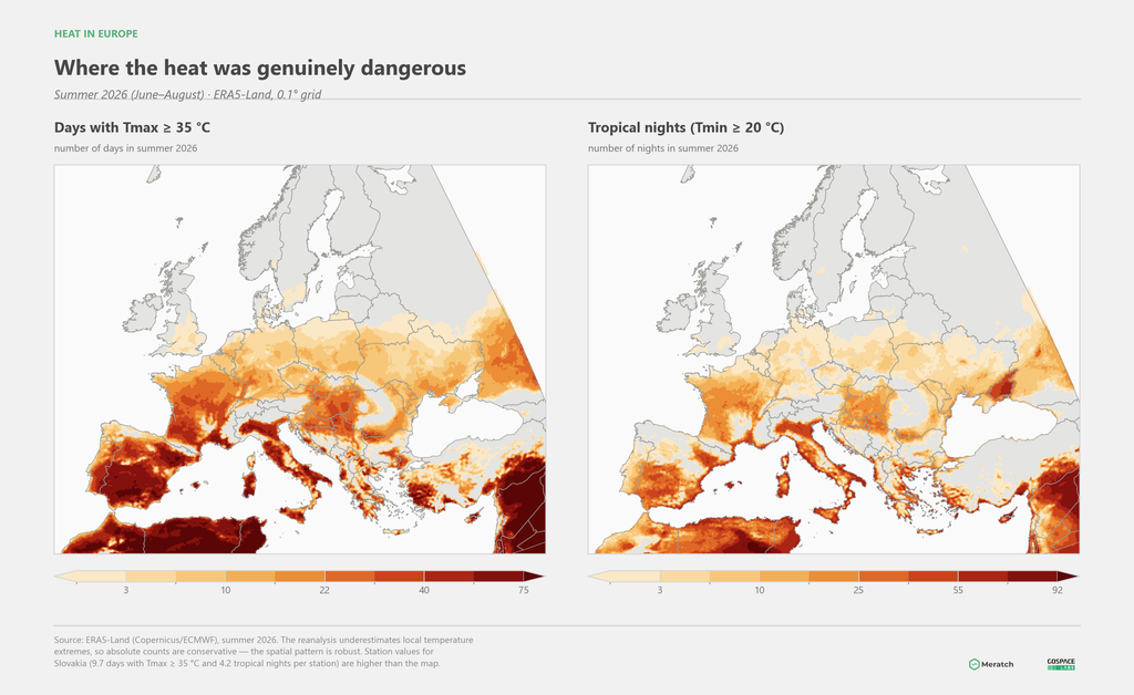
On a European scale, Slovakia sat at the edge of the core. The most days above 35 °C occurred over the Iberian Peninsula, southern France, Italy and the Balkans; tropical nights concentrated along the Mediterranean coast, where the sea released the heat it had accumulated all summer. The World Weather Attribution analysis of the June European heatwave showed something that applies to us as well: daytime maxima in Europe are rising roughly three times faster than the global mean temperature, and night-time minima about twice as fast. Compared with 2003 — still the symbol of lethal heat — today’s daytime heat is about ten times more likely, and night-time heat more than a hundred times more likely.
What that means in people: the summer of 2022 cost Europe more than 60,000 heat-related deaths, the summer of 2023 more than 47,000. The June 2025 wave alone caused an estimated 2,300 deaths in twelve European cities.
Why this drought was different
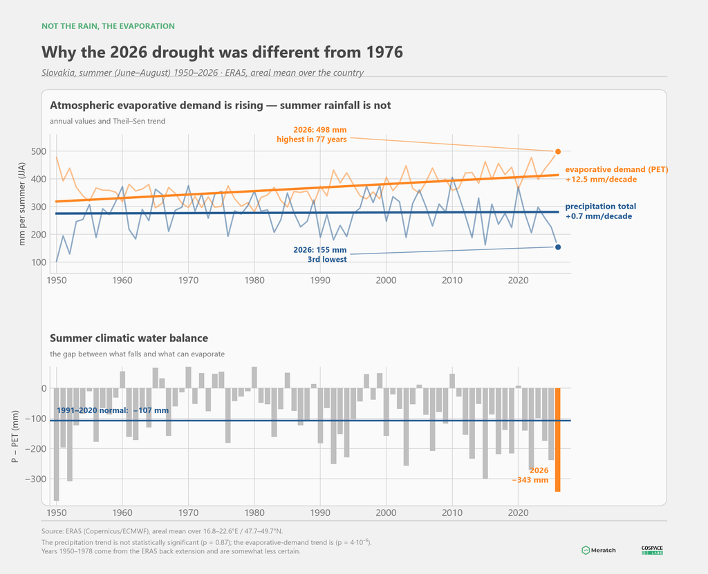
Here is the core of it. Looking at summer rainfall in Slovakia over the past 77 years, there is no statistically significant trend — +0.7 mm per decade, with p = 0.87, statistically indistinguishable from zero. The rainfall deficit of summer 2026 was year-to-year variability, of the kind that also occurred in 1976 and 2015.
What does have a trend, and a strong one, is the atmosphere’s evaporative demand — potential evapotranspiration. It is rising by 12.5 mm per decade (p = 4·10⁻⁶) and in summer 2026 reached 498 mm, the highest value in the entire 1950–2026 record.
The consequence is fundamental. The climatic water balance — the difference between what falls and what can evaporate — ended at −343 mm against a normal of −107 mm. In other words: the same rain leaves substantially less water in the soil today than it did four decades ago. Rainfall deficits that used to cause no drought now cause one.
The chain that produced summer 2026 ran like this:
- An empty store at the start — the driest winter and spring in 76 years.
- A persistent ridge of high pressure — subtropical air reached further north than in any of the past 77 years, and the cold troughs that normally interrupt heatwaves appeared on four days in a hundred instead of the usual twenty-four.
- Record solar radiation — over both Central and Western Europe the surface received more energy than in any of the past 77 years.
- Record evaporative demand — and the soil dried out so far that actual evaporation nonetheless fell (by 33 mm below normal in Slovakia). The surface switched into a moisture-limited regime: the atmosphere wanted to evaporate more, but there was nothing left to evaporate.
- The feedback — energy that could no longer go into evaporation went into heating the air instead. 17 W/m² more than usual was diverted into sensible heat. Soil temperature at Hurbanovo reached 27.4 °C at 5 cm depth in August (+5.1 °C above normal) and a maximum of 48.8 °C at 2 cm — a surface behaving like a hotplate, not like moist ground.
That last step is why the absolute maxima climbed so high. In a normal summer, part of the energy that drove the temperature to 42.2 °C on 6 August would have gone into evaporating water from soil and vegetation.
And the same feedback closes the loop: heat dries the soil, and dried soil intensifies the heat. Drought and heatwave are no longer two separate phenomena. They are two expressions of one process.
The European context
Slovakia was not an exception — it was part of a continental-scale event. Summer 2026 was the warmest in the entire 1950–2026 record in 16 European countries and in Europe as a whole. France finished at +3.9 °C above normal, Italy at +3.1 °C, Hungary and Austria at +2.7 °C, Slovakia, Czechia and Germany at +2.2 °C.
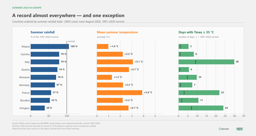
In rainfall terms the worst affected was Hungary (39 % of normal), followed immediately by Slovakia (53 %). The only country in our neighbourhood that stayed outside the core of the anomaly was Poland — 106 % of normal rainfall and “only” +1.0 °C. A reminder that the boundaries of such events are sharp, and that a neighbour’s experience need not transfer.
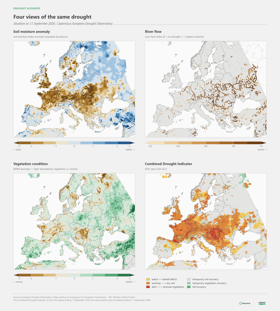
Looking at the situation through the Copernicus European Drought Observatory, four indicators tell the same story from four angles. Soil moisture shows a continuous dry belt from France through the Alps to the Carpathians and the Pannonian Basin. River flow — the Low-Flow Index, modelled over the river network — marks the same rivers that carried record-low summer discharges. Vegetation condition confirms that the deficit reached the crops themselves. And the Combined Drought Indicator places much of Central Europe and France in the “alert” class, meaning a rainfall deficit that has already progressed through dry soil to damaged vegetation.
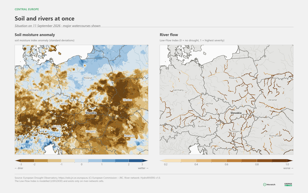
Zoomed to Central Europe, the picture is sharply drawn: Slovakia, Hungary, Austria and southern Czechia deep in the dry range, Poland on the wet side of normal.
The World Weather Attribution initiative published an analysis of the April–June European drought in July 2026 that arrived at the same mechanism as our own data. In Western Europe it found no statistically significant long-term decline in rainfall; by its account the drought is driven exclusively by rising evaporative demand. The quantification is telling:
- soil drought is now about 5 times more likely in Western Europe and 11 times more likely in the East than in a climate 1.4 °C cooler,
- the high-evaporation conditions themselves are ~80× (west) and ~40× (east) more likely,
- the intensity of evaporative demand is 7–8 % higher,
- with a further +1.4 °C, intense evaporative conditions in Western Europe will be another 10× more likely than today.
One detail matters. In Western Europe the rainfall deficit was a once-in-25-year event. The evaporative demand was a once-in-50-year event. The shortage of rain was unremarkable; the thirst of the atmosphere was not.
Our own attribution analysis for Slovakia, built on the three longest station records (Hurbanovo and Boľkovce from 1872, Liptovský Hrádok from 1881), gives the same picture: a summer with this mean temperature, this number of tropical days and tropical nights would have been practically impossible in a pre-industrial climate. Tropical nights are now almost 30× more frequent, tropical days 4.3×. For health impacts the first of those numbers matters more than the second — it is the absence of night-time cooling that makes heatwaves lethal.
What it cost
The impacts were not hypothetical. From phenological observations the Slovak Hydrometeorological Institute reports yields 10–40 % lower and failure of spring forest plantings; from hydrology, zero flows on small streams and historically unprecedented summer discharges on the Danube. Across the wider continent, Romania lost more than a million hectares of maize, France recorded its lowest maize harvest in 50 years, several countries imposed emergency water rationing, and low river levels restricted cargo shipping.
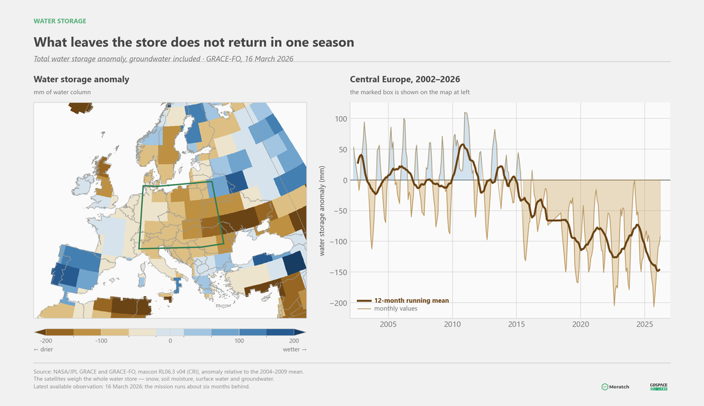
And there is a longer arc behind the single season. The GRACE and GRACE-FO satellites weigh the total water store — snow, soil moisture, surface water and groundwater together. Over Central Europe that store has been falling steadily since roughly 2015 and now sits some 140 mm below the 2004–2009 average. This is the part of the drought that a single wet autumn does not repair.
Part two — is Slovakia prepared?
We measure well. We have nothing to act on
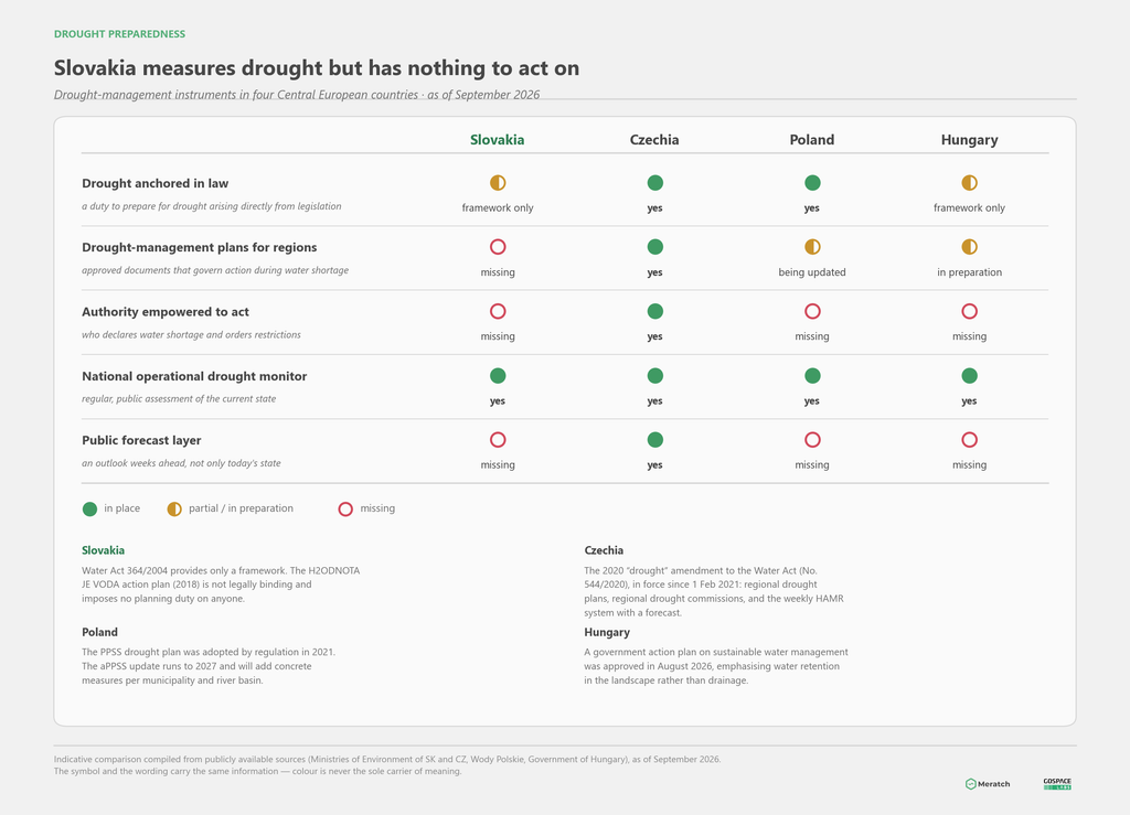
The answer in one sentence: Slovakia knows how severe its drought is. But it has no document that governs what to do about it, and no authority empowered to act.
The Slovak Hydrometeorological Institute runs drought monitoring that is professionally sound. An Action Plan for Addressing the Consequences of Drought and Water Scarcity — H2ODNOTA JE VODA — was approved by the government in 2018 as the first cross-sectoral document on the subject, with a costed requirement of more than €140 million. Water Act 364/2004 provides a general framework.
What is missing is the connection between them: the action plan is not legally binding and imposes no planning duty on anyone. There are no drought-management plans for regions or river basins, no authority that would declare a state of water shortage and order restrictions, and no public forecast layer — an outlook weeks ahead rather than a statement of today’s condition.
How the neighbours stand
Czechia is furthest ahead in the region, and the difference is institutional rather than technical. The so-called “drought” amendment to the Water Act (No. 544/2020), in force since February 2021, introduced drought plans as binding operational documents and regional drought commissions empowered to decide during water shortage. Regional plans were to be drawn up by the end of 2023, and a national plan was assembled from them. The technical layer is supplied by the HAMR system (Hydrology – Agronomy – Meteorology – Retention), developed jointly by the T. G. Masaryk Water Research Institute, CzechGlobe, the Czech University of Life Sciences and the Czech Hydrometeorological Institute, which computes indicators weekly and — unlike our monitoring — also provides a forecast.
Poland adopted its drought plan (PPSS) by regulation in 2021, making it legally binding. The first version contained mainly general recommendations and a retention agenda; the update running to 2027 is to add concrete measures for individual municipalities and river basins together with an operational dimension — what to do once drought arrives.
Hungary, the worst affected this year in rainfall terms, approved a government action plan on sustainable water management in August 2026. Its centre of gravity is a shift from draining water away to retaining it in the landscape and in the soil — precisely what Hungary has long lacked.
At European level the European Commission is preparing drought-assessment indicators and technical guidelines for drought-management plans under its Water Resilience Strategy, intended to harmonise member-state approaches. The decisive point remains that drought-management plans are not mandatory in the EU — and it is exactly this that World Weather Attribution identified as the main reason for inconsistent preparedness across the Union.
Five priorities that should come first
1. Convert the action plan into a binding instrument. Without a planning duty and a designated authority, any drought document remains a recommendation. The Czech model from 2020 shows this is not especially demanding — it is a matter of political decision, not technical capacity.
2. Add a forecast to the monitoring. The difference between “there is drought today” and “there will be drought in ten days” is the difference between reaction and decision. Small water-supply systems fail on the daily peak, not on the annual balance — and that is exactly where a few days of notice change the outcome.
3. Shift measures from water supply to water demand. If drought is driven by evaporative demand rather than declining rainfall, then enlarging storage alone does not solve the problem — it addresses only one end of it. Equally important are measures that reduce evaporation and increase retention in the soil: soil organic matter, ground cover, agroforestry, wetland restoration, removing sealed surfaces in settlements.
4. Measure where decisions are made. Gridded reanalyses and satellite products give a picture, but not an answer to how much water is in this field or beneath this spring. Combining local sensors with satellite and model data is now affordable both technically and financially.
5. Tie the warning to a specific decision. A warning that does not end with “do this” is not a warning but a piece of information. For a water utility that means the timing of restrictions, activating a backup source, filling a reservoir against the daily peak, booking tankers. For a municipality, watering and planting dates. For a farmer, irrigation dose and timing.
What we are doing about it
It is exactly that last step — from measurement to decision — that our work at Meratch is built on.
DroughtScope (or Droughter) is our product line for drought and flash drought, built on the same platform as our flood product Floodar. That is not a coincidence: baked dry soil has lower infiltration, so the first heavy rain produces higher and faster runoff. Drought and flash flooding are two ends of the same soil-moisture axis, and one data layer serves both products.
What already exists and runs:
- Drought risk maps for the whole of Europe at 1 km resolution and for Slovakia at 250 m, in an agricultural / hydrological / flash-drought / aggregate product family. Validated against observed severe drought episodes (2003 and 2022), the hazard component reaches an AUC of 0.82–0.86.
- Flash-drought monitoring — rapid dry-down that develops within days to a fortnight and that conventional monthly monitoring catches only once it is too late.
- An operational multi-hazard overview from the ECMWF run, holding heat, drought, flash flooding and fire risk in a single picture.
- Our own low-cost sensors — soil moisture probes, rain gauges, level sensors and LoRa gateways, field-proven in flood deployments.
What we are building next: a forecast layer with a 14-day outlook, thresholds and escalation tied to specific decisions, and an irrigation assistant that answers the question “when, and how much”.
European projects
We consider it important that none of this develops in isolation from the people who are meant to use it. That is why we take part in European funding calls.
GOSPACE LABS is currently submitting a proposal to the LIFE programme in the field of climate change adaptation. Its centre of gravity is not a tool but pilot deployment with real users — a water utility in municipalities where supply is already under pressure, and municipalities that manage urban greenery. Each pilot comes with a network of measuring points, a menu of decisions with the thresholds that trigger them, at least one physically implemented adaptation measure, a decision log, and an independent evaluation of what changed relative to current practice — measured in restriction days, abstraction from sources, tanker deliveries, and watering volumes.
The proposal builds on the lesson of an earlier, unsuccessful submission: reviewers then objected that the project was too much “about the tool” and too broad, with a weak link to measures actually implemented and without end users as active partners. This time the use case is narrow, the baseline quantified, and the users are in the consortium.
Summary in three sentences
The 2026 drought did not arise because it rains less and less in Slovakia — summer rainfall has no statistically significant trend. It arose because the atmosphere’s evaporative demand is rising by 12.5 mm per decade, so the same rain leaves less and less in the soil; and once the soil dries out, it stops cooling by evaporation and amplifies the heat itself.
Slovakia can measure such a drought but has no binding document governing what to do about it and no authority empowered to act — unlike Czechia, which has had this anchored in law since 2021.
Changing that takes two steps at once: an institutional one (binding plans and clear responsibility) and an operational one (forecast instead of description, warning tied to a specific decision). We are working on the second.
Analytical basis: Regional Climatological Institute and GOSPACE LABS. Data sources: station network of the Slovak Hydrometeorological Institute (AWS and APS), the KMIS archive 1872–2025, the SHMÚ radar composite, ERA5 and ERA5-Land (Copernicus/ECMWF), Copernicus European Drought Observatory, NASA/JPL GRACE-FO. European attribution results: World Weather Attribution (July 2026).
